Climate Change in Australia
Climate information, projections, tools and data
Climate model resolution
A climate model is a mathematical representation of the climate system. Equations are solved at points on a 3-dimensional grid in the ocean and atmosphere, over a number of time-steps.
Spatial resolution specifies the horizontal size of the grid cells (in degrees of latitude and longitude or in km).
Temporal resolution refers to the size of the time steps used in models; how often (in simulated or "model time") calculations of the climate variables are calculated.
Read more about model design and methods for obtaining high resolution (downscaled ) results.
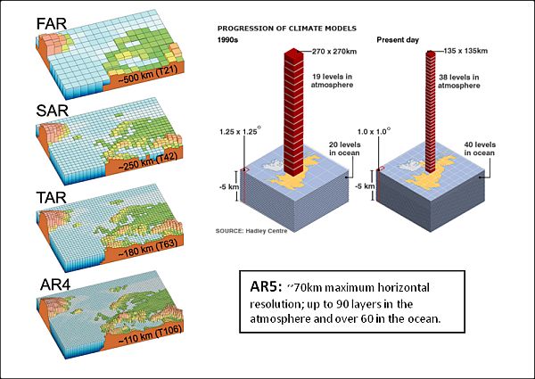
The figure below illustrates the advances made in typical spatial resolution used in state-of-the-art climate models around the times of each of the first four Assessments of the Intergovernmental Panel on Climate Change. Resolution improved from about 500km in 1990 (FAR = First Assessment Report), to as fine as 110km in 2007 (AR4 = Fourth Assessment Report). Current CMIP5 models assessed in the IPCC Fifth Assessment Report (AR5) have a finest horizontal resolution in the atmosphere of around 70km, but the average is about 200km. The vertical resolution has also improved over the years. For the First Assessment Report from the IPCC models had a single-layer "slab ocean" and 10-15 atmospheric layers while Fourth Assessment Report models often included 30 layers in the oceans and another 30 in the atmosphere. Current CMIP5 models assessed in the AR5 have a vertical resolution in the atmosphere of 20-50 levels.

Progress in resolution of models (left) and an example of resolution of current generation models (right) SOURCE: IPCC AR4 (2007) Working Group I The Physical Science Basis and UK Met Office (Hadley Centre)
Regional Climate Models (RCMs) can be employed to increase resolution even further. RCMs represent all the atmospheric physics of GCMs but are run only over a smaller area and can therefore have higher resolution (from 60 km down to below 10 km). Typically an RCM is ‘embedded’ within a host GCM, which provides the large scale climate fields e.g. sea surface temperatures, wind and pressure fields, needed to drive the RCM. This is usually referred to as the GCM providing the ‘boundary conditions’ for the RCM.
As a general rule, increasing the resolution of a model by a factor of two means about ten times as much computing power will be needed, as the resolution must be increased in all three spatial dimensions, and temporal resolution must also be increased. Such a model will take ten times as long to run on the same computer.
------------
Page updated 17th December 2020


