Climate Change in Australia
Climate information, projections, tools and data
Comparison with Climate Change in Australia 2007
This page compares the climate change projections conducted by CSIRO and the Bureau of Meteorology in 2007, as published in the Climate Change in Australia Report (2007), and on the previous version of this website (archived here ), with the projections published on this website and in the Climate Change in Australia Projections for Australia’s NRM Regions reports .
The Climate Change in Australia 2007 (CSIRO and BoM 2007) described future climate using probability density functions (PDFs). To read more about the methodology used to derive projections in 2007 read Section 4.2.6 of the Climate Change in Australia 2007 Report.
Since 2007 projections a new generation of global climate models has become available to the climate modelling community, along with new descriptions of greenhouse gas and aerosol emissions scenarios . These scenarios are used to drive climate models, therefore it can be difficult to make direct comparison between projections using the previous emissions scenarios (called SRES scenarios), and the current Representative Concentration Pathways (RCPs).
Comparison of results

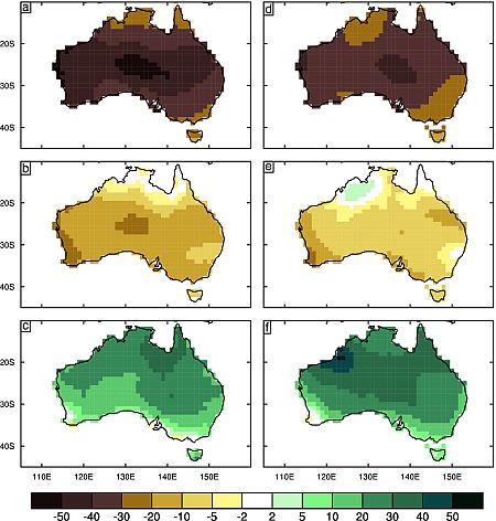
An example comparison that can be found in the Technical Report Appendix A. This figure shows change in rainfall (in %) from CMIP3 (left) and CMIP5 (right). Three percentiles of the local PDFs for change are shown: (A & D) 10th, (B & E) 50th and (C & F) 90th.
Appendix A of the Technical Report compares projected changes based on CMIP5 with those based on CMIP3, as used for Climate Change in Australia (CSIRO and BOM, 2007). In 2007, the range of change in each variable was presented in a probabilistic form, with the change at each location, for a given scenario and time in the future, being represented as a probability density function (PDF). The method used relies on the pattern scaling approximation, as described in Section 6.2 of the Technical Report , with further details given by Watterson (2008). In order to derive comparable results the method is applied again using CMIP5 data. The range in the PDFs allows for both the uncertainty in the global warming and in the local response to it (or ‘change per degree’), with both factors based on the ensemble of models. For CMIP3, 23 models were used, while suitable data are available from up to 40 CMIP5 models . For some variables, the local response factors were derived from fewer models, as noted below. The model change per degree data are first interpolated to a common one-degree grid of points at which the local changes are calculated.
Results are presented for six surface variables that are important to climate impacts. The focus is on the Australian maps of annual changes for three percentiles, the median, denoted P50, and the P10 and P90 values representing the upper and lower values across the likely range.
Figure from Appendix A can be found on the Publication Library's Figures and Maps page.
Page updated 20th December 2020


