Climate Change in Australia
Climate information, projections, tools and data
About Monsoonal North
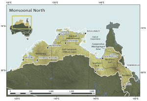
The Northern Monsoon cluster covers 1906 km2 and includes NRM regions across Queensland (NQ Dry Tropics, Northern Gulf, Southern Gulf and part Cape York NRM), the Northern Territory (part of Territory NRM) and Western Australia (part of WA Rangelands). It extends across the entire Australian continent from the Burdekin River in Queensland to the Fitzroy Basin in WA, and comprises the majority of Australia’s dry tropical savanna’s. Major land uses and activities include agriculture, pastoralism, mining, oil and gas, tourism, recreation and nature conservation. Approximately half of the land base is owned or managed by Indigenous people.

Background to Research
In mid 2013 a workshop in Darwin brought together representatives from all NRMs within the Northern Monsoon cluster and the research team to identify and prioritise what research and knowledge was required. The result was a set of nine co-developed and well targeted sub-projects to support NRM planning. These are reflected in the RESEARCH OUTPUTS.

Key Messages & Issues
The Northern Monsoon Cluster is aiming to provide improved knowledge, tools and management options to NRM bodies to enable them to better adapt to the challenges imposed by a changing climate. It aims to do this by working to:
- Identify and access regionally relevant expertise and information on climate change impacts and potential adaptation responses;
- Integrate local and Indigenous knowledge and experience with regionally relevant science in understanding climate change impacts, and working through opportunities and potential adaptation responses;
- Plan for the future impacts of climate change and capitalise on the opportunities provided by the CFI and the Landcare Fund to improve the long term resilience of regional landscapes, biodiversity, communities and economies;
- Strengthen their capacity and achieve a high level of uptake of research knowledge to support the development of well-informed NRM plans;
- Make use of higher quality NRM planning processes and products;
- Build long-term relationships with key researchers, other information providers and NRM planners, that will have an enduring benefit beyond the life of the project; and
- Provide a legacy for future work through information, tools and networks plus a model of research and NRM partnerships.


