Climate Change in Australia
Climate information, projections, tools and data
About Wet Tropics
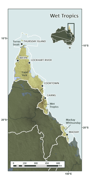
The Wet Tropics NRM Cluster includes four NRM regions across north-eastern Queensland. It extends from the Mackay-Whitsunday-Isaac region in the south to the Torres Strait islands in the north, excluding areas of dry topics around Townsville. The Wet Tropics NRM region includes low-lying coastal areas, inland plains and subcoastal ranges and contains globally significant savannas, the vast majority of Australia’s tropical rainforests, wetlands and low lying tropical islands. The Cluster region contains the Wet Tropics and Great Barrier Reef World Heritage Areas, as well as a high proportion of the Great Barrier Reef catchment.


Key Messages & Issues
Along with very high biodiversity values, there are numerous and substantial economic and cultural values including extensive and intensive agriculture, tourism, mining, and large areas of Indigenous lands. Much of the NRM Cluster’s area is ‘highly contested’ with multiple and sometimes conflicting demands for the region’s natural resources. Climate change is likely to exacerbate the issues and challenges.
- Both extensive and intensive primary production are likely to be challenged by climate change requiring adaptations in where, what and how food is produced in the region. The possible adaptation responses of this sector – as all others – will have important effects, positive or negative, on other sectors.
- The Indigenous population of the Cluster is high relative to many other parts of Australia, ranging from 12-90% across the NRM regions. Climate change will impact Indigenous people in many ways, including through changes to ‘country’ that affect physical and mental well-being and cultural practices. In addition to climate change, a range of other urgent and pressing issues affect Indigenous community welfare.
- Coastal communities, especially those located on low-lying islands (e.g., Torres Strait) are particularly vulnerable to sea level rise and increasingly intense storm surges caused by more extreme weather.
- Natural resource management in the regions covered by this cluster has long been contentious due to its highly contested values in multiple sectors. The need for climate change adaptation in most of these sectors accentuates the challenge and requires an integrated approach.
Background to Research
Wet Tropics Cluster NRM groups convened a meeting in 2012 to articulate their priority information needs in relation to climate change impacts and adaptation research and NRM planning. During 2013 and 2014, representatives from NRM groups in the Wet Tropics Cluster identified additional detail in relation to their information needs during two workshops. These were used to develop the research project Knowledge to manage land and sea: A framework for the future. NRM priority information needs continue to be updated throughout the project and in relation to specific research projects. Key research projects in the Wet Tropics Cluster include:
- A synthesis report on scientific knowledge around climate change issues and impacts
- A synthesis report on Adaptation pathways and opportunities
- Planning and implementation of participatory scenario planning processes
- Traditional owner heritage mapping and engagement in planning processes
- Spatial tools and products for optimising biodiversity benefits of investment in carbon plantings


